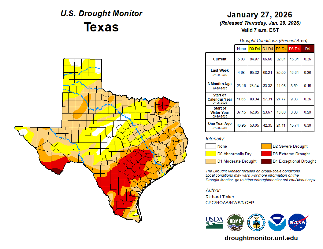
DROUGHT INDEX: In the latest release of the Texas Drought Monitor, issued on Thursday, January 29, 2026, crippling drought conditions are occurring across Central and Southeast Texas.
In the Brazos Valley, ‘Moderate’ to ‘Extreme’ drought conditions spread across the Brazos Valley, even the wake of cooler, icy weather. Residents should use caution burning outdoors, as conditions are still very dry locally, even as most counties have lifted their areawide burn bans.
Stay with Madison County, Texas Weather for the latest weather and tropical developments, including: current radars, watches, warnings, advisories, and severe weather coverage.
Current Burn Bans: Austin and Robertson Counties! Current Watches, Warnings, & Advisories: None!
Forecast Discussion: Thursday brought warmer, sunny weather across Southeast & Central Texas, allowing for the warmest day in nearly a week after a massive Arctic weather system left Texas cold and powerless. Temperatures reached the 50s and 60s areawide Thursday afternoon across the Brazos Valley. For those that love the colder weather, the warm air doesn’t last long, as our next round of Arctic air moves through the Lone Star State. The Eastern United States likely finds an Arctic mess of snowy and icy conditions, but here in the South, we have a very cold (and different) story.
Our next Arctic cold front moves into the Brazos Valley arrived Friday evening, bringing blustery, windy weather to begin the upcoming weekend. Temperatures fall into the upper teens to middle 20s Saturday and Sunday mornings, with the latter becoming the coldest day of the weekend for the Brazos Valley. Either way, a couple nights of hard freezes are expected through the upcoming weekend. Be sure to drip your faucets and bring in your outdoor pets Friday and Saturday nights. This latest round of Arctic air will be very cold, isn’t expected to bring icy or snowy weather to the Brazos Valley. Saturday is expected to be very cold, with highs in the middle-to-upper 30s areawide. Temperatures rebound to the 50° mark Sunday afternoon, with highs moving back into the 60s next week. Highs near the 70° late Tuesday before a rain chance arrives Tuesday night and temperatures cool midweek.
5-Day Weather Outlook: Friday: High 51. Low 26. Mostly Sunny, Cooler. Saturday: High ↓ 38. Low 18. Sunny, Very Cold. Sunday: High 50. Low 31. Sunny, Cool. Monday: High ↑ 64. Low 48. Mostly Sunny, Warmer. Tuesday: High 68. Low 45. Mostly Cloudy. 20% Chance/Rain.
Stay with Madison County, Texas Weather for the latest weather and tropical developments, including: current radars, watches, warnings, advisories, and severe weather coverage.
Madison County, Texas Weather has provided area-wide residents with the latest weather and tropical developments for Madison County, Texas, alongside other portions of the Brazos Valley since since October 12, 2012.
Madison County Texas Weather strives to provide area-wide viewers with the latest weather and tropical developments. In addition, MCTXWeather is there when severe weather strikes, bringing you the latest severe weather coverage, radars, watches, warnings, and advisories. Madison County, Texas Weather appreciates the local and area-wide support from it’s viewers on social media.
On Facebook viewers can find the latest details on daily forecasts, 48 hour outlooks, weather previews, watches, warnings, advisories, the tropics, severe weather, drought index’s, and more on our social media accounts: Facebook, Twitter, & Instagram, and our website.
Stay with us throughout the day, as we bring you the latest!
Madison County, Texas Weather
Letting Us Help Plan Your Day Since October 12, 2012!
NOTE: Madison County, Texas Weather is not affiliated to any local Madison County, Texas governmental agencies and has never claimed to be. The views or statements posted by Facebook users on our page do not necessarily represent those of Madison County, Texas Weather.
Negative comments will be subject to review and action(s) may be taken if comments seem to be threatening, liable, or hateful towards others. Madison County, Texas Weather serves the right to ban any person(s) from this page if viewers feel threatened or harmed. Please refrain from rude, vulgar, and hateful language/material. Thank you for your courtesy!
Madison County, Texas Weather Team
Founder/Owner/Weather Forecaster: Coy Bailey II
Area-Wide Weather Watchers: Angie Filoteo, Tammy Sapp
Madison County, Texas Fire Watcher: Tammy Sapp
Tropical Weather Watcher: Coy Bailey II